Vul. Pidvalna – Vynnychenka Street Greenway (formerly Governor’s Ramparts) ID: 2005
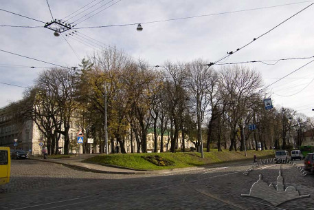
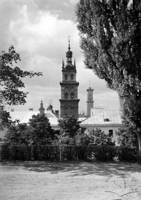
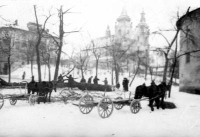
Along the eastern end of the Lviv fortifications’ site, where the Governor’s Ramparts once stood, lies a greenway tucked between Pidvalna and Vynnychenka Streets. In 1821, gubernatorial counselor Reitsenheim led the initiative to establish the greenway on the leveled rampart slopes. In the 1850s, strong winds leveled old-growth trees in the park; the park was later renovated with a design from municipal horticulturist Karl Bauer.
Story
The park on the Governor’s Ramparts sits at the most heavily reinforced section of the eastern end of Lviv’s ancient walled fortifications. (Toward the close of the 18th century, the ruins here were used in a way similar to those at the Hetman ramparts – as landfill for leveling the territory and filling in fortress trenches, however the so-called “Porokhova Vezha” (Gunpowder Tower), a municipal and royal arsenal, has survived until the present day).
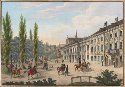
By the early 19th century, “at the eastern end, past the Bosatskyi Gate, a garbage mound fills the crumbling ramparts. It has collapsed into a complete ruin.” Order began to be restored to the territory on the occasion of Emperor Francis I’s visit to Lviv. “In honor of Emperor Francis’s arrival in 1816, the square on Panska Street (currently Vynnychenka) which today is graced by the Regent’s House, was leveled and landscaped” (Stankiewicz, 1928, 64-65). Governor’s Ramparts got their name when Governor Franz von Hauer settled in the new home of the state administration which stood nearby.
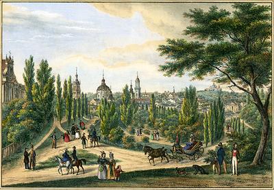
After the windstorm in the 1850s that leveled the old growth trees, the ‘eastern ramparts’ were re-landscaped under the direction of the head of the municipal gardens Karl Bauer. The greenway followed the line of the slopes built up from Pidvalna Street and which, from the top, afforded excellent views of central Lviv.
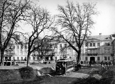
During the last third of the 19th century, with the placement of the tramline and the construction of new regency offices, Governor’s Ramparts took on a more contemporary look.
At the beginning of the 20th century, “Veterans of the Bureaucracy” – retired government workers – frequented the Governor’s Ramparts, relaxing on the walks and benches in the park adjoining the offices of the Regency where they had once labored. In contrast to the Hetman Ramparts, which functioned as a main thoroughfare in the Ringstraße mode, the Governor’s Ramparts have long maintained a more relaxing, quieter atmosphere, just as it had in the early 19th century.
After Ivan Franko Park, the Pidvalna-Vynnychenka Street greenway is the second oldest planned park in the city.
Architecture
On modern maps of Lviv, the greenway built on the former Governor’s Ramparts appears as a leafy stretch running between the parallel streets Pidvalna and Vynnychenka. The territory runs north-south with a gentle rise toward Zamkova Hora (Castle Hill).
The Governor’s Ramparts greenway was established on filled in ground where fortifications often referred to as the “Royal Belvoir” (Fr., belvoir, “beautiful view”) had once stood. The topography of the territory continues to bear the marks of its ‘fortified’ past; the Gunpowder Tower and the City Arsenal nearby, both stand on the territory. The old German gymnasium school (currently, Public School #8) is also in the park.
The impressive silhouettes of notable churches – the Voloska Church, the Dominican Church, and the Discalced Carmelite Church – dominate park sightlines. The Governor’s Ramparts acquired its more modern look toward the end of the 19th century with the laying of the tramline on Valovyi Street and the construction of a new Regency Office building. It was thanks to the efforts of regency counsel Reitsenheim who initiated the plan to establish a green lane “on the eastern ramparts” that, already in the early 20th century, it could be reported that “Italian poplar, chestnut, and other greenery cover the crown of the hill, and flourish the length of this nearly century-old lane…” (Jaworski, 1911, 256). Yet another report states that the 3.05 hectare Governor’s Ramparts park had “a straight lane, planted in linden, chestnut, and maple” (Kowalczuk, 1896, 319).
In the 1940s, Olena Stepaniv states that “on the gradually sloping land there are old-growth linden, chestnut, ash, maple, and acacia” (Stepaniv, 1992, 48).
Together with the lane through the Hetman Ramparts (Svobody Prospect), the Governor’s Ramparts greenway running between Pidvalna and Vynnychenka Streets form the first, inner ring of Lviv parkland zone. The second ring is formed by Ivan Franko Park and Vysokyi Zamok, Znesinnya, Lychakiv, Pohulyanka, Zalizna Voda, and Stryiskyi Parks.
People
Karl Auer. Artist, lithographer.
Karl Bauer. Landscape architect, park
designer.
Franz von Hauer. Governor.
Wilhelm Reitzenheim. Government counselor.
Olena Stepaniv. Historian, geographer, civic
activist.
Franz I. Austrian Emperor.
Franciszek Jaworski. Historian.
Sources
- Ivanochko, U. et al. “Architecture of the late 18th and first half of the 19th Centuries.” Architecture of Lviv: Times and Styles, 13th-21st centuries. Biriulyov, Yuryi, ed. Lviv: Center of Europe Publishing, 2008. 170-237. Print.
- Krypyakevych, Ivan. Historical Walks Around Lviv. Lviv: Kamenyar, 1991. Print.
- Stepaniv, Olena. Contemporary Lviv: A Guidebook. Lviv: Phoenix, 1992. Print.
- Barański, F. Przewodnik po Lwowie: Z planem i widokami Lwowa. Lwów: 1902. Print.
- Jaworski, F. Lwόw stary i wczorajszy (szkice i opowiadania): Z ilustracyami. Wydanie drugie poprawione. Lwów: 1911. Print.
- Kowalczuk, M. “Rozwόj terytoryalny miasta.” Miasto Lwów w okresie samorządu 1870–1895. Lwów: 1896. 299–351. Print.
- Orłowicz, M. Ilustrowany przewodnik po Lwowie: Ze 102 ilustracjami i planem miasta. Wydanie drugie rozszerzone. Lwów – Warszawa: Książnica-Atlas, 1925. Print.
- Stankiewicz, Z. ”Ogrody i plantacje miejskie.” Lwów dawny i dzisiejszy: Praca zbiorowa pod redakcją B. Janusza. Lwów: 1928. 62–71. Print.
